How Long Is a Nautical Mile?
If you’ve ever wondered, “how long is a nautical mile?” you’re not alone! It’s not something we hear about every day unless you’re into sailing or aviation. Simply put, a nautical mile measures distance at sea or in the air and is different from the miles you might track on your car’s odometer.
What Is a Nautical Mile?
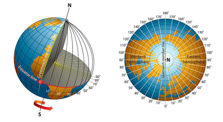
A nautical mile is a special way to measure distance used by sailors and pilots. It’s based on the Earth’s shape and how we divide the planet using lines called latitude and longitude. These lines help us map the globe. A nautical mile equals 1 minute of latitude—that’s one-sixtieth of the distance between two lines of latitude. If we measured from the North Pole to the equator, it would be 21,600 nautical miles because there are 60 minutes in a degree and 360 degrees around the Earth.
To put it simply: 1 nautical mile is 6,076 feet or about 1.1508 regular (statute) miles.

How Is a Nautical Mile Measured?
The nautical mile is tied to the Earth’s geography, specifically its curvature. Our planet isn’t a perfect sphere; it’s a bit flattened at the poles, like an oblate spheroid. Because of this, nautical miles are more accurate for navigation at sea and in the air. This measurement system works globally, no matter where you are, thanks to its connection to longitude and latitude.
The International Hydrographic Organization officially set the length of a nautical mile to 1,852 meters (or 6,076 feet) during a hydrographic conference in Monaco in 1954. Before this, different countries used slightly different lengths, which made navigation tricky.
Nautical Mile vs Statute Mile: What’s the Difference?
So, how does a nautical mile compare to the regular mile you use on land, called a statute mile? The key difference lies in what they measure:
- A statute mile is 5,280 feet and is used for distances on land.
- A nautical mile is 6,076 feet and is used for distances over water or in the air. It’s based on the Earth’s latitude and longitude system, not fixed land measurements.
For example, if you were navigating a ship or flying a plane, using nautical miles makes it easier to calculate distances based on the Earth’s surface. It’s all about precision when moving across such vast areas.
Why Are Nautical Miles Used in Navigation?
Nautical miles are especially helpful because they directly link to the Earth’s geography. Ships and planes navigate using maps that are based on the curvature of the Earth. Since a nautical mile is tied to latitude, it works seamlessly with charts and GPS systems to measure distances and plan routes.
This system also helps determine speed. For example, “knots” are the speed equivalent of nautical miles. If a ship travels at 1 knot, it’s moving at 1 nautical mile per hour. That’s why nautical miles and knots are the standard for navigation at sea and in the air.
A Bit of History: Where Did the Nautical Mile Come From?
The idea of a nautical mile goes back to ancient times when sailors used the stars and horizon for navigation. However, the term wasn’t officially standardized until much later. During the 1954 hydrographic conference in Monaco, the world agreed to adopt the international nautical mile, making it the same length everywhere.
The use of latitude and longitude dates back even further, to when explorers mapped the globe. Dividing the Earth into degrees, minutes, and seconds helped navigators understand their position and how far they needed to travel. The minute of arc—or one-sixtieth of a degree—became the foundation for the nautical mile.
Applications of the Nautical Mile in Modern Times
Today, nautical miles are used in maritime and aviation industries to measure distance. Whether it’s a cargo ship crossing the Atlantic or an airplane flying coast to coast, nautical miles keep navigation consistent worldwide.
They’re also essential for calculating accurate routes and speeds. For example, knowing that there are 60 minutes of latitude in a degree helps captains and pilots figure out their exact position on the map. This is a universal system that connects all navigators, regardless of where they are on the planet.
Conclusion
So, how long is a nautical mile? It’s 6,076 feet or about 1.1508 statute miles. This unique measurement, based on the Earth’s latitude and longitude, plays a vital role in navigation at sea and in the air. Whether you’re piloting a plane, steering a ship, or just curious about how sailors and aviators measure their journeys, the nautical mile is a fascinating tool that bridges geography and exploration.
By understanding the minute of latitude, the history of the nautical mile, and how it’s used today, you’ll have a clearer picture of how people navigate the world.
Also Read This: What Is Parametric Rolling in Container Ships?


